

Renewable Resource Data Now Available for Free Download
Newsletter
Today, IRENA launched a new version of the Global Atlas for Renewable Energy, the online renewable energy mapping platform. For the first time, the platform allows users to download resource data for offline analysis, and to print and export map images.
With these enhancements, the Global Atlas now offers a complete suite of services to support renewable resource mapping and assessment, including an online GIS interface, datasets for five renewable energy technologies that cover every country in the world, online analysis tools, and the ability to export data and maps in several different formats.
The Global Atlas provides access to more than 2,000 datasets for free, but previously users could only view this data graphically on a map, or get a numerical value for a single point. Now users can also download the raw data (in selected datasets*) for further analysis and use. The data download feature is available in geographical blocks of 4 MB, and provides a GeoTIFF file which users can upload to their own GIS systems to conduct further analysis.
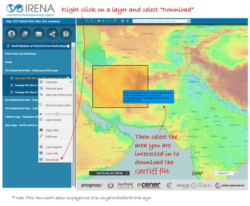
New data download feature
The new version of the Global Atlas also provides a print and export feature, so users can easily incorporate data-rich maps into their publications and presentations. Users can select which data layers and geographic area they are interested in, and then preview and edit a print version of their map before saving it, exporting to Word, or downloading an image file. The download image feature includes a composite image as well as separate image files for each GIS layer.
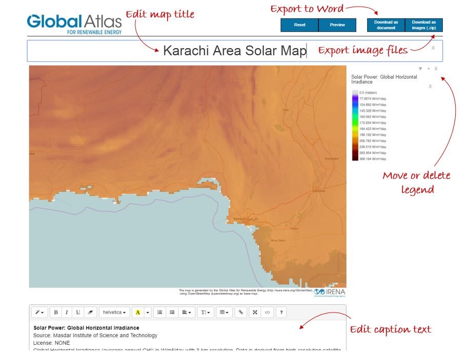
The print feature allows you to print, export to Word, or export image files
Other new features include easier sharing via social media, an improved search algorithm, and a way for advanced users to tag their maps with a “fitness for use indicator” that can help others determine the appropriate use for the data, according to the Global Atlas Data Quality Strategy.
For more information about these new features, please see our latest Global Atlas newsletter and/or register for our technical webinar on May 18, 2016 at 7 pm GST.
---------
*Datasets in the following maps are currently available for download. To suggest or request other layers for download, please email potentials@irena.org.
- Global Wind Atlas (DTU) (map 103)
- HelioClim3v4 solar data (ARMINES/MINESParisTech) (map 529)
- Uruguay National Solar Atlas (Solar Energy Laboratory, Uruguay) (map 1405)
- Mozambique solar map (Eduardo Mondlane University) (map 1153)
- Wind atlases by CENER (map 422)
All ESMAP country maps (World Bank Group):
- Vietnam (map 1705)
- Pakistan (map 1706)
- Maldives (map 1707)
- Malawi (map 1708)
- Zambia (map 1709)
- Tanzania (map 1710)
- Ethiopia (map 2291)
- Afghanistan (map 2292)
- Papua New Guinea (map 2293)
Regional Suitability analyses (IRENA):


